Wednesday, June 9, 2010

Hiri Mount Maluku

Hiri Mount is forest island with wide 3 km,  its area at north  of Ternate Island , Maluku Archipelago.  Hiri Mount  at  northside of  volcanic archipelago  in west Halmahera Island. And this Mount is a volcanic cone,  its high 630 m in south of  Gamalama Mount.
Ternate (Indonesian: Pulau Ternate) is dominated by the volcanic Mount Gamalama (1715 m). The volcano erupts regularly, covering the island with volcanic dust. Major past eruptions of Gamalama include 1673, when a large, but undetermined number of people were killed, and 1772, when about twenty inhabitants died. The largest recent eruption of Gamalama was in September 1980, when 30,000 of the islands 56,000 residents were forced to temporarily flee to nearby Tidore. The island now has an area of 76 square kilometres (29 square miles) and held a population estimated at 145,143 in July 2003. The town is located at 0°47?N 127°22?E. 

Tuesday, June 8, 2010

Toba Lake North Sumatra


Toba Lake is a volcanic lake its  length around 100 kilometers and 30 kilometers wide, located in North Sumatra province, Indonesia. This lake is the largest lake in Indonesia and Southeast Asia. In the middle of this lake there is a volcanic island called Samosir Island.

Toba Lake has long been an important object tourism  beside Bukit Lawang in North Sumatra and Nias, Domestic and foreign tourists attracted.
Toba Lake happened estimated  when the explosion occurred around 73000-75000 years ago and is the eruption Supervolcano . Bill Rose and Craig Chesner from Michigan Technological University estimate that volcanic materials of the mountain spit out as much as 2800 km ³, with 800 km ³ of ignimbrit rock and 2,000 km ³   the volcanic ash and   its was brought  by the wind to west for two weeks. Volcanic dust was brought  by wind has spread to half the earth, from China to South Africa. The explosion occurred during one week and throw dust reaches 10 km above sea level.
Photos by Chmouel, he said :
I, Chmouel, took the photo when I was traveling in Sumatra Indonesia, more pictures of Sumatra and Toba Lake can be found here:

Monday, June 7, 2010

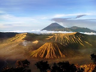
Bromo mount


Bromo Mount (from Sanskrit : Brahma, one of the main Hindu gods), is still an active volcano and  famous as a tourist attraction in East Java. As a tourist attraction, Bromo Mount become attractive because  its status as a still active volcano.
Bromo  height  is 2392 meters above sea level and its located in four regions namely  Probolinggo, Pasuruan, Lumajang, and Malang. Bromo  Mount has  sands zone  approximately 10 square kilometers.
Bromo Mount crater has diameters  ± 800 m (north-south) and ± 600 meters (east-west). And the danger area is a circle with a radius  4 km from the central crater of Bromo.

During the 20th century, the mountain  erupted three times, with regular intervals 30 years. The biggest eruptions   in 1974,and  the last eruption  in 2004.

Bromo residents  namely Tengger tribe, Brahma Mount (Bromo)  believed to be the sacred mountain. Once a year the community held a ceremony Yadnya Tengger Kasada or Kasodo. This ceremony is held at a temple which is under the northern foot of Bromo Mount and  then ceremony  was continued to the summit of Bromo. The ceremony was held at midnight to early morning every full moon around the 14th or 15th of the month Kasodo (tenth) according to the Java calendar.

Monday, May 31, 2010

Juata Laut beach, Tarakan.


Tarakan Town is one of town in East Kalimantan province, Indonesia.
Tarakan is a island, its located at north region of East Kalimantan, near Malaisia.
Because it is a isle, often get high wave threat.
But Tarakan has beautiful places. One fo them is Juata Laut beach.
First in Tarakan has stood a Empire its name Kerajaan Tarakan Tidung.
Now Tarakan is developing. pursuing its expectation, that is :
Clean, Peaceful, Beautiful, Healthy, and prosperous.

Above photo from : http://www.kaskus.us/showthread.php?t=873557&page=55

Bontang


Bontang is a town  in East Kalimantan Province, Indonesia. The town  located about 120 kilometers from Samarinda, directly adjacent to the East Kutai regency at the north and west, Kutai Kartanegara Regency to the south Makassar Strait to east. Geographically 0.137 ° LU    117.5 ° BT 

In this town stand three large companies at different fields, Badak NGL (natural gas), East Kalimantan Fertilizer (fertilizer and ammonia), and Indominco Mandiri (coal) and has  petrochemical industrial area called the Kaltim Industrial Estate. Bontang town is oriented in the industrial, services and trade.


Beside Photo is Sejadah Island. Sejadah Island is one of beautiful places in Bontang.
This photo is creation by M.R. Taufik, and he wrote in her blog my.opera.com :
A small sand island near to Bontang Kuala. This island is amazing! The water is very clean and clear. You can reach this island by small boat in 20 minutes from Bontang Kuala. Make sure that you visit this island while ebb sea, that is condition not high water or tide


If you would like to know farther please visit :
Photo 1 from : http://abuizzulislam.blogspot.com
Photo 2 from : http://dinaisme.multiply.com
Photo 3 from : http://my.opera.com/

Saturday, May 29, 2010

Balikpapan

Balikpapan is one town of East Kalimantan.
Balikpapan is beautiful town, it has many object tourism. 
This photo is one of coasts in Balikpapan town, its name "Pantai Kemala", beautiful in dusk.
Balikpapan face to  Makassar strait. This strait sometime has  high wave.

Balikpapan producer of oil. There are two refinery in bay of Balikpapan.
Refinery Balikpapan I and  II.
Refinery Balikpapan I   yield Naphta, kerosene, gasoline, diesel, and residue of parafinic destilate oil ( POD )
Refinery Balikpapan II yield  LPG, Naphta, kerosene, diesel, and residue.
If you would like to visit Balikpapan, please by plane from Jakarta. 
And Balikpapan around 102 km from Samarinda.

Photo 1 from : http://www.inijie.com/
Photo 2 from : http://diahngesti-balikpapan2009.blogspot.com/
Photo 3 from : http://cyberedhoy.blogspot.com/
Photo 4 from : http://kpmbyogya.wordpress.com/

Kutai Katranegara bridge, Tenggarong


It is beautifull Kutai Katranegara bridge on Mahakam river Tenggarong town. It’s not far from Samarinda, around 30 minutes  by car or motorcycle.

Tenggarong is a  sub-district   becoming  capital town   of Kutai Kartanegara, East Kalimantan, Indonesia. Kutai Kartanegara is divided in 13 sub-district have wide of region 398,10 km2 with amount inhabitant  72.458 (BPS 2007)

Tenggarong  also Sultanate capital town  of Kutai Kartanegara  ing Martadipura . This town founded on 28 September 1782 by King of Kutai Kartanegara  15th, Aji Muhammad Muslihuddin, and his call   is Aji Imbut

The firt this name town is Tepian Pandan then to be Tangga Arung ( King House ) and then this town populer with called Teggarong until now.
                                                              Tenggarong Map
Tourism object in Tenggarong

    * Museum Mulawarman
    * Museum Kayu Tuah Himba
    * Pulau Kumala
    * Planetarium Jagad Raya
    * Jembatan Kutai Kartanegara
    * Waduk Panji Sukarame
    * Makam Raja-Raja Kutai