Tuesday, June 22, 2010

Dubai


The United Arab Emirates (UAE) is a union of seven states, called Emirates. One of these states, and perhaps the most progressive, is Dubai. Some records actually indicate that Dubai has been in existence for about one-and-a-half centuries before the UAE was formed.
There are very few accounts of the culture that prevailed in the southeastern part of the Arabian peninsula prior to the time of Islam. The evidences and accounts gathered so far have sufficed in the meantime to make some headway in tracing back the history of Dubai.
The discovery, for instance, of some material traces of an ancient mangrove swamp (estimated at 70 centuries) during the laying of the sewer lines near the Dubai Internet City on Sheikh Zayed Road led to the conclusion that the area had been blanketed by sand some fifty centuries ago as the coastline receded inland. This has now become a part of Dubai's present coastline.
Some records indicate that many of the old places in that southeastern part of the Arabian peninsula served as trading centers between the East and the West. Before the time of Islam, the region was dominated by the Azd (a pre-Islamic Arabian tribe). The Azd worshipped Bajar, a minor deity.
During that period, two powers lorded it over the region. These are the Byzantine (Eastern Roman) and the Sassanid (Persian) empires. The latter controlled a big part of the region.
When much of the region was converted to Islam, the Umayyad Caliphate took control of the region from the Sassanids. The Dubai Museum undertook excavations in the region of Jumeirah and discovered a number of material evidences believed to be from the period of the Umayyads.
Other historical records indicate that Dubai was established by the Al Abu Falasa lineage of Banu Yas clan in the early 19th century. Until 1833, Dubai was a dependent of Abu Dhabi (now one of the 7 states and the capital of UAE). The sheikh of Dubai, along with the other sheikhs of the region, signed the "General Maritime Treaty" with the government of Britain on January 8, 1820. Thirteen years later, the Al Maktoum dynasty (also a lineage of the Banu Yas clan) left Abu Dhabi and took control of Dubai from the Al Abu Falasa clan. 
Today, Dubai is a vibrant city teeming with mega construction projects. It has become a favorite tourist destination and a strong trading center in the world. But despite this transformation to modernity, Dubai has retained its rich Islamic culture.
Photo 1 from : http://cultblogforsheilasnblokes.wordpress.com/2009/04/
Photo 2 from : http://portaledu.wordpress.com/2010/01/04/26-projek-terbesardubai/
Photo 3 from : www.propertyinvesting.net

Prambanan Temple


When you think about beautiful temple, we will inform you about a fascinating temple, he is the Prambanan. This temple is located on Java, Indonesia

Approximately 10 km east of Yogyakarta, 40 km west of Surakarta and 120 km south of Semarang, exactly on the border between the Central Java province  and Yogyakarta. Prambanan is located in districts  Sleman and Klaten. Rara Jonggrang or Lara Jonggrang temple located at Prambanan. Prambanan is the largest Hindu temple complex in Indonesia
This temple was built in about the year 850 AD, believed this temple was built by Rakai Pikatan the second king of Mataram dynasty or Balitung Maha Sambu, during the Sanjaya dynasty.

Prambanan 47 meters high, the main temple is Shiva temple (center),  Brahma temple (south), the Vishnu temple (north).    In front of them ther are Wahana temples (vehicle) as vehicles  Trimurti, Temple Space is the vehicle of Brahma ( Guardians God ),  Nandi temple (Ox) is the vehicle of Shiva (Destroyer Gods) and the   Garuda temple is the vehicle of Vishnu ( Creator God )
This temple is very beautiful and fascinating. If you go there like visiting the place of the gods. As if we go a long way to heaven is full of beauty.
I hope the information above is to please you. If you go to Indonesia don’t forget to visit Prambanan.
Photo 1 From :  http://www.panjalu.net/ 
Photo 2 From :  http://merahmay.wordpress.com

Monday, June 14, 2010

Komodo Island

Komodo is an island in West Nusa Tenggara archipelago, Komodo dragons live in here. This island is also the Komodo National Park which is managed by the Central Government. Komodo Island to the west of Sumbawa Island, Sape strait between them

This island including Komodo subdistrict, West Manggarai regency, East Nusa Tenggara Province, Indonesia. Komodo Island is the western end of  East Nusa Tenggara Province, bordering with West Nusa Tenggara province.


Komodo dragons flourish very well here. Until August 2009, on this island there are about 1,300 Komodo dragons. If combined with other islands, namely  Rinca island and Gili Motang, all of them are about 2500. There are also around 100 Komodo dragons  at Wae Wuul preserve on the  Flores island, but here was not included  the Komodo National Park area.


Komodo dragon (Varanus komodoensis) is the largest lizard, its length reaching three meters  and weighs about 70-90 kg. Komodo happy to live in holes in the ground, sometimes under rocks or under tree roots. These reptiles can move fast and run above ground, but can also swim in the water


Photo 1 from : http://www.lablink.or.id/Env/Satwa/stw-komodo.htm
Photo 2 from : http://anril.com/lokasi_indonesia.php
Photo 3 from : http://riseafterfall.wordpress.com/2009/07/13/vote-komodo/
Phutu 4 from : http://www.itravelindonesia.com/pollforthebest.aspx

If you would like to know farther visit : http://www.komododiving.com/index.html

Saturday, June 12, 2010

Nile Egypt ( Sungai Nil Mesir )


If us hear of Egypt, hence we will remember with story of  Pharaohs and Mozes. ( Firaun dan Musa )

Egypt is a country  in Africa bank of the Nile river, Egypt famous because Pharaohs and Mozes story along with their relic pyramids and temples, and also Egypt famous because beautiful Nile river.
Aswan is the ancient city in Egypt, in this city there are the royal tomb. Nobles build a necropolis of rock cut stones on the high cliffs on the west bank of the Nile.
                                          Mortuary temple queen Hatsheput

The river Nile is longest river in the word, every year the Nile flooded at almost exactly the same time of year, 15th July. Then Egypt government build a dam to cope with the flood in Aswan city, construction began in 1960 and completed on 1970, called Aswan Dam.

Capital city of Egypt is Cairo, pretty town on the bank of the  Nile, you will be spellbound  Let’s go to Egypt
                                          Cairo beautiful city

Other photos : http://www.aegyptenbilder.de/fotos.html  ( this site accommodate many Egypt photos )


Wednesday, June 9, 2010

Indonesia volcanoes

                                               Semeru mount Java
Beautiful photos  Indonesia volcanoes are very charming and amaze. Every one will be interested. If you would like to know about Indonesia volcanoes farther, please read this article below and visit its link.
                                              Agung mount Bali
The geography of Indonesia is dominated by volcanoes that are formed due to subduction zones between the Eurasian plate and the Indo-Australian plate. Some of the volcanoes are notable for their eruptions, for instance, Krakatau for its global effects in 1883,  Lake Toba for its supervolcanic eruption estimated to have occurred 74,000 Before Present which was responsible for six years of volcanic winter,  and Mount Tambora for the most violent eruption in recorded history in 1815. 


                                  Galunggung 1982
Volcanoes in Indonesia are a part of the Pacific Ring of Fire. The 150 entries in the list below are grouped into six geographical regions, four of which belong to the volcanoes of the Sunda Arctrench system. The remaining two groups are volcanoes of Halmahera, including its surrounding volcanic islands, and volcanoes of Sulawesi and the Sangihe Islands. The latter group is in one volcanic arc together with the Philippine volcanoes.       

                                 Kerinci mount Sumatra
The most active volcanoes are Kelut and Merapi on Java island which have been responsible for thousands of deaths in the region. Since AD 1000, Kelut has erupted more than 30 times, of which the largest eruption was at scale 5 on the Volcanic Explosivity Index (VEI),  while Merapi has erupted more than 80 times. TheInternational Association of Volcanology and Chemistry of the Earth's Interior has named Merapi as a Decade Volcano since 1995 because of its high volcanic activity

Hiri Mount Maluku

Hiri Mount is forest island with wide 3 km,  its area at north  of Ternate Island , Maluku Archipelago.  Hiri Mount  at  northside of  volcanic archipelago  in west Halmahera Island. And this Mount is a volcanic cone,  its high 630 m in south of  Gamalama Mount.
Ternate (Indonesian: Pulau Ternate) is dominated by the volcanic Mount Gamalama (1715 m). The volcano erupts regularly, covering the island with volcanic dust. Major past eruptions of Gamalama include 1673, when a large, but undetermined number of people were killed, and 1772, when about twenty inhabitants died. The largest recent eruption of Gamalama was in September 1980, when 30,000 of the islands 56,000 residents were forced to temporarily flee to nearby Tidore. The island now has an area of 76 square kilometres (29 square miles) and held a population estimated at 145,143 in July 2003. The town is located at 0°47?N 127°22?E. 

Tuesday, June 8, 2010

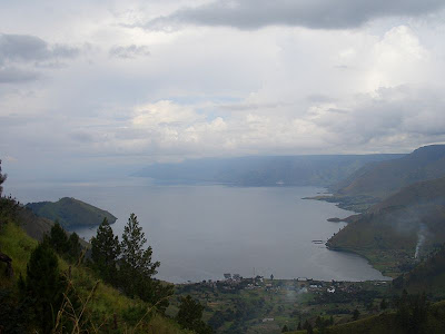
Toba Lake North Sumatra


Toba Lake is a volcanic lake its  length around 100 kilometers and 30 kilometers wide, located in North Sumatra province, Indonesia. This lake is the largest lake in Indonesia and Southeast Asia. In the middle of this lake there is a volcanic island called Samosir Island.

Toba Lake has long been an important object tourism  beside Bukit Lawang in North Sumatra and Nias, Domestic and foreign tourists attracted.
Toba Lake happened estimated  when the explosion occurred around 73000-75000 years ago and is the eruption Supervolcano . Bill Rose and Craig Chesner from Michigan Technological University estimate that volcanic materials of the mountain spit out as much as 2800 km ³, with 800 km ³ of ignimbrit rock and 2,000 km ³   the volcanic ash and   its was brought  by the wind to west for two weeks. Volcanic dust was brought  by wind has spread to half the earth, from China to South Africa. The explosion occurred during one week and throw dust reaches 10 km above sea level.
Photos by Chmouel, he said :
I, Chmouel, took the photo when I was traveling in Sumatra Indonesia, more pictures of Sumatra and Toba Lake can be found here:

Monday, June 7, 2010

Bromo mount


Bromo Mount (from Sanskrit : Brahma, one of the main Hindu gods), is still an active volcano and  famous as a tourist attraction in East Java. As a tourist attraction, Bromo Mount become attractive because  its status as a still active volcano.
Bromo  height  is 2392 meters above sea level and its located in four regions namely  Probolinggo, Pasuruan, Lumajang, and Malang. Bromo  Mount has  sands zone  approximately 10 square kilometers.
Bromo Mount crater has diameters  ± 800 m (north-south) and ± 600 meters (east-west). And the danger area is a circle with a radius  4 km from the central crater of Bromo.

During the 20th century, the mountain  erupted three times, with regular intervals 30 years. The biggest eruptions   in 1974,and  the last eruption  in 2004.

Bromo residents  namely Tengger tribe, Brahma Mount (Bromo)  believed to be the sacred mountain. Once a year the community held a ceremony Yadnya Tengger Kasada or Kasodo. This ceremony is held at a temple which is under the northern foot of Bromo Mount and  then ceremony  was continued to the summit of Bromo. The ceremony was held at midnight to early morning every full moon around the 14th or 15th of the month Kasodo (tenth) according to the Java calendar.